responsive website templates

Stonehenge is one of the most enigmatic prehistoric monuments in Britain, but it is important to remember that the stones themselves are only part of a much bigger picture.

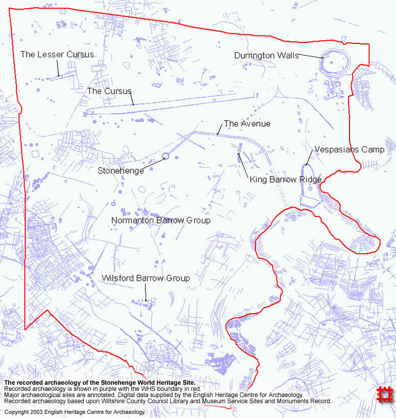
The landscape around Stonehenge is rich in archaeological sites of all periods, hundreds of them, including barrows and cursuses from prehistoric times, Romano-British camps, medieval field-systems and more recently the railways and the remains of the Stonehenge Aerodrome including some hangar footings, testament to continued use and re-use of the space. It is due to the internationally recognised importance of this archaeological landscape that UNESCO have designated the area a World Heritage Site.

The recorded archaeology of the World Heritage Site.

 In addition to this and previous episodes of fieldwork, desk-based computer studies have looked at patterns of visibility within the landscape as a means to furthering our understanding (eg Wheatley, 1995; Batchelor, 1997; Exon et al 2000). Much of the vast corpus of accumulated knowledge was collated and reinterpreted in the mid-nineties as part of a project involving Wessex Archaeology and English Heritage, culminating in the publication of Stonehenge in its Landscape (Cleal et al. 1995).

Mobirise Website Builder

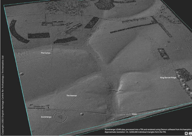
Stonehenge LiDAR data, processed into a 3D surface model ready for analysis. Major archaeological features are annotated. Original data supplied by the Environment Agency with additional processing by Archaeoptics and the English Heritage Centre for Archaeology.

A recent addition to the corpus of data regarding the Stonehenge landscape has also been produced using similar laser-scanning technology to that used to identify the new carvings: A laser-scanner attached to a helicopter or aeroplane combined with GPS technology in a system referred to as LiDAR (Light, Distance And Ranging) was used to produce a detailed terrain model of the World Heritage Site. This dataset can be analysed in a similar way to the digital surface models of the stones using a three-dimensional analytical system such as Demon from Archaeoptics or a CAD-based system. 

In addition, the dataset can be used as a traditional DTM (Digital Terrain Model) within GIS, providing a variety of map-based analytical functions. The resolution of this data and the relative ease of capture compares favourably with existing data sources, allowing large areas of landscape to be captured as three-dimensional surface data facilitating a scientific, analytical approach to the landscape.

Of course, such an approach to the Stonehenge landscape is not the only one. The Stonehenge landscape and the stones themselves have been the focus for a number of interest groups over the years, an example of the way in which a single place can mean many things to many people. While the extensive Hippy festivals of the 1970’s and 1980’s are no more, the Henge is open to the public for the summer solstice celebrations, attracting a wide diversity of people from all kinds of backgrounds. In this way, the landscape is not a fossilised ‘timeless’ landscape, as some would have it, but the current outward expression of a continuous dynamic process of interaction between people and their environment. Arguably, the only difference between our own experience and that of our predecessors being that our modern compartmentalisation of forms of interaction (into ritual vs everyday, for example) may not have been at all applicable in the past (eg Gibson et al. 1998). Indeed, the Neolithic and Bronze ages, when many of the monuments were created, was a time of flux, with a changing social consciousness (Bradley. 1998), both being exhibited in and controlled/legitimised by various forms of monumental architecture.
To conclude then, Stonehenge is far more than just a henge in isolation: There are in fact three other henges within the World Heritage Site (Woodhenge, Durrington Walls and Coneybury Henge) and a multitude of other sites. This represents the surviving outward expression in the landscape of the complex and dynamic patterns of interaction between people in the past and the landscape in which they found themselves, the physical remains deeply endowed with meaning and significance gained and lost over time; a process still ongoing today as different interested parties continue actively engaging with and renegotiating the landscape and its diverse meanings in terms of their own understandings and intentions.

References

  1. Batchelor, 1997. Mapping the Stonehenge World Heritage Site. Proceedings of the British Academy, 92. pp61-72.
  2. Bradley, R. The Significance of Monuments: On the Shaping of Experience in Neolithic and Bronze Age Europe . London: Routledge.
  3. Cleal, R. Walker, KE. & Montague, R. 1995. Stonehenge in its landscape; Twentieth-century excavations. London: English Heritage.
  4. Exon, S. Gaffney, V. Woodward, A & Yorston, R. Stonehenge Landscapes: Journeys Through Real and Imagined Worlds. CD-ROM version. Oxford: Archaeopress
  5. Gibson, A. & Simpson, S. (eds.) Prehistoric Ritual and Religion. Stroud: Sutton Publishing.
  6. Richards,J. 1990. The Stonehenge Environs Project. (HBMCE Archaeological Report 16). London: English Heritage
  7. Wheatley, DW. 1995. Cumulative viewshed analysis: a GIS-based method for investigating intervisibility, and its archaeological application. in Lock, GR and Stancic, Z (eds.) Archaeology and Geographic Information Systems: A European Perspective, London: Taylor and Francis, pp. 171-186.

© Copyright 2003- Archaeoptics/Wessex Archaeology - All Rights Reserved